
Day Trip to Grand Canyon Village
It's a roughly two-hour drive from Sedona to the Grand Canyon Village and Mather Point area of the canyon's southern rim. Formed by the Colorado River, the canyon reveals nearly two billion years of geological history. It descends over a mile in depth and spans 277 miles in length. Mather Point makes an excellent starting point to walk along the rim. Walkways extend for several miles on either side of Grand Canyon Village, offering convenient access to iconic viewpoints. Although the photos here are very scenic, they don't fully capture the canyon's vast and overwhelming beauty. During our tour, we traveled by bus and car to various points along the rim on both sides of the Village, and enjoyed an easy walk between clearly marked viewpoints.
Click on an image to pop up a larger version.

The View From Mather Point (1)
The Grand Canyon stretches roughly 277 miles along the Colorado River, reaches widths of up to 18 miles, and maintains an average depth of one mile.
The View From Mather Point (4)
It is estimated that the Colorado River began carving the canyon approximately 5 to 6 million years ago.
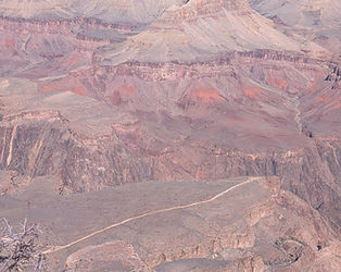
Looking to the Canyon Floor
The North Rim sits at approximately 8,800 feet, which is about 1,000 feet higher than the South Rim, leading to heavier snowfall on the north side.
Canyon Village Path Look Out
These 3 layers represent different geological eras, from ancient crustal formation to tectonic shifting, and finally to millions of years of oceanic and desert deposits.
Hopi Store at the Village
Numerous archaeological sites, including granaries and dwellings, are still visible along the cliffs today.

The View From Mather Point (2)
Near Mather Point and the adjacent Grand Canyon Village area, the canyon is approximately 10 miles (16 km) wide from rim to rim.
The View From Mather Point (5)
The Vishnu Basement Rocks at the bottom of the Inner Gorge are nearly 2 billion years old, representing almost half of Earth's history.
Looking to the Canyon Floor
Layers like the Kaibab Limestone are rich with fossils of brachiopods, crinoids, and coral.

Trail View Overlook
The canyon sits on the Colorado Plateau, a tectonic block uplifted thousands of feet without much tilting or folding. This 'tectonic quiet' keeps the rock layers mostly horizontal.
Canyon Wall and a Tree
Not related to the picture, the Village of Supai, located in Havasu Canyon, is the capital of the Havasupai Indian Reservation and is inaccessible by road.

The View From Mather Point (3)
It is approximately 7 miles via the Bright Angel Trail, though it is only about 2.5 miles as the crow flies to the River.
People on the Edge of the Rim
The Colorado River carries massive amounts of sediment that act as abrasives, cutting through rock layers to form the canyon.
Mid-Level Canyon Path
The canyon's walls consist of three layers: the metamorphic basement rocks at the bottom, the tilted sedimentary layers in the middle, and the horizontal Paleozoic strata on top.

Grand Canyon Village
Native American tribes, including the Puebloan, Hopi, and Havasupai, have considered the canyon home for thousands of years.

Yavapai Point View
At Yavapai Outlook, the Geology Museum, originally built in 1928 as an observation station, serves as an educational hub for understanding the canyon's geological history.