

Day 1 on the Rocky Mountaineer
June 25, 2025

The train day itinerary is straightforward: wake up early, take the bus to the station, and board the train for a roughly 10-hour journey filled with scenic views, food, and drinks. We selected the Goldleaf service, which features a two-level train car and upgraded food and beverages.
The passenger cars appear to be customized for this experience. The upper level has large observation windows and very spacious seating, while the lower level is a comfortable dining area serving an elegant breakfast and lunch. There's also a covered open-air observation deck on the lower level, perfect for photos. Although the fresh air was enjoyable in June, rain made it less pleasant at times.
One downside of passenger train travel (in general and not specific to Rock Mountaineer) is that freight trains have priority. This led to travel delays, and we arrived in Kamloops late, missing dinner. On the plus side, in Kamloops, we spent the night at a reasonable hotel (not on the train), and our luggage was transferred directly to our hotel for us.
As usual, I took hundreds of photos, selecting a few of the better ones to display and describe below.
Click on an Image to pop up a larger version.
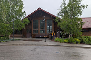
Lake Louise Train Station
This station was built in 1910 to serve tourist traffic. It was declared a heritage railway station in 1991. It opened as a restaurant in 1994. It is now also used to board Rocky Mountaineer trains.

Open Air Vestibule
This photo is confusing; the grass and plants at the top appear to be reflections on the shiny ceiling. The vestibule is an outdoor viewing platform, letting passengers enjoy fresh air and scenery.

Rafting on Kicking Horse River
Rafting on the Kicking Horse River is known for its fast-moving water and technical rapids. The river is divided into upper, middle, and lower sections, each providing increasingly challenging whitewater.

Along Side Kicking Horse River
The Kicking Horse River is a tributary of Canada's Columbia River. Starting in southeastern British Columbia and flowing for 80 km (50 mi) through Yoho and Kootenay National Parks.

Shuswap Lake Shoreline
Shuswap Lake, shaped like a capital "H," drains into Little Shuswap Lake via the Little Shuswap River, which feeds the South Thompson River. Its four arms are Seymour, Anstey, Salmon, and West.

Main Seating/Observation
Rocky Mountaineer's GoldLeaf service, shown in this image, features two-level coaches. The main upper-level seating is under a panoramic glass ceiling that provides expansive views.
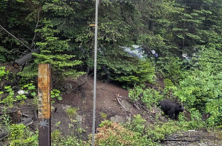
A Bear Rumaging Around
Black bears use train tracks as travel routes and are attracted to spilled grain from cargo trains, as well as the abundance of berry-producing shrubs along the side of the railway.

Canadian Hwy Crossing Kicking Horse.
For most of the journey, the train tracks run parallel to the Trans-Canadian Highway. In this photo, we go underneath it.

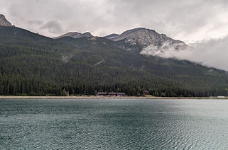
Kinbasket Lake
Kinbasket Lake is a reservoir on the Columbia River in southeast British Columbia. The lake is a flooded valley with trees, towns, and bridges underwater.

Notch Hill Loop
The Notch Hill Loop is a spiral railway loop built in 1981. It was designed to reduce the grade from 1.8% to 1% to accommodate longer trains. It also offers a good photo opportunity of the train.

Lower Level Dining Area
The lower level of the train car is a separate, dedicated dining area where breakfast and lunch are served. We thought the dining choices and desserts were excellent.
Wapta Lake
Wapta Lake is a glacial lake in Yoho National Park and is a primary source for the Kicking Horse River. The Trans-Canada Highway runs along the north shore. Our train travels on the south side.

Monument for the Last Spike
The Last Spike monument at Craigellachie, British Columbia, marks the completion of the Canadian Pacific Railway on November 7, 1885.

Eagle River
The Eagle River originates in the mountains west of Revelstoke. It flows west and southwest, feeding Shuswap Lake.

South Thompson River
The South Thompson River starts at the outlet of Little Shuswap Lake. It runs about 58 km (36 mi) southwest to Kamloops, where it merges with the North Thompson River.